This is default featured slide 1 title

Go to Blogger edit html and find these sentences.Now replace these sentences with your own descriptions.

This is default featured slide 2 title

Go to Blogger edit html and find these sentences.Now replace these sentences with your own descriptions.

This is default featured slide 3 title

Go to Blogger edit html and find these sentences.Now replace these sentences with your own descriptions.

This is default featured slide 4 title

Go to Blogger edit html and find these sentences.Now replace these sentences with your own descriptions.

This is default featured slide 5 title

Go to Blogger edit html and find these sentences.Now replace these sentences with your own descriptions.

Showing posts with label Geography. Show all posts

Saturday, August 4, 2012

Changu Narayan Temple

Changu Narayan, that is situated on a small hillock is full of magnificent design and arts in metal and wood. Well among all the best example of Nepalese arts and architecture it is one of them. In 1979 A.D. it was listed in the World Heritage site.

After moving 6Km north of Bhaktapur you will find this beautiful and historic temple of Changu Narayan. Although it is mentioned that it was built on 1702 AD (when it was rebuilt), it was really originated right back from 4th century. Lots of stones and sculpture were built during Licchavi period. It is believed that in 323 King Hari Datta Verma built it. Not only its beauty attract visitor but also lots of visitor visit there to see its scenario, and now a days any one can drive right to the temple via Bhaktapur. Alternatively you can visit the temple by walking from the town or you can visit by walking down from Nagarkot.

You can find ancient stone steps there that will lead you to the top of the hill. On the top you will see a large square courtyard, where you will find the temple that is double roofed which is dedicated to the incarnation Vishnu, Narayan. Garuda is found in the in front of temple. Stone lion guard the wonderfully glided door.
Various types of images of Vishnu like narsingha, his man lion incarnation and Vikranta, striding across the universe are found their. the statues of King Bhupalendra Malla and his queen is found, kneeling in a glided cage in front of the temple.

Quick Share -- http://on.fb.me/McyCds

Say Something About It.

Monday, November 21, 2011

Mount Everest, "The Roof Of The World"

In 1856, the Great Trigonometric Survey of British India established the first published height of Everest, then known as Peak XV, at 29,002 ft (8,848 m). In 1865, Everest was given its official English name by the Royal Geographical Society upon a recommendation by Andrew Waugh, the British Surveyor General of India. Waugh named the mountain after his predecessor in the post, Sir George Everest. Although Tibetans had called Everest "Chomolungma" for centuries, Waugh was unaware of this because Nepal and Tibet were closed to foreigners.

The highest mountain in the world attracts many well-experienced mountaineers as well as novice climbers willing to hire professional guides. While not posing substantial technical climbing challenges on the standard route, Everest presents dangers such as altitude sickness, weather and wind.

 By the end of the 2010 climbing season, there had been 5,104 ascents to the summit by about 3,142 individuals. Climbers are a significant source of tourist revenue for Nepal, whose government also requires all prospective climbers to obtain an expensive permit, costing up to US$25,000 per person. By the end of 2010 Everest had claimed 219 lives, including eight who perished during a 1996 storm high on the mountain. Conditions are so difficult in the death zone—altitudes higher than 8,000 metres (26,000 ft)—that most corpses have been left where they fell. Some of them are visible from standard climbing routes.

   Rumours have been heard that Mt Everest is located in India or in China. But the true fact is that Mt Everest was always in Nepal, is in Nepal And always will be.

- View over Himalaya and Mount Everest, from an airplane flying from Bhutan to Kathmandu in Nepal.


Hillary and Norgay Climb Mount Everest (1953):
       After years of dreaming about it and seven weeks of climbing, New Zealander Edmund Hillary and Nepalese Tenzing Norgay reached the top of Mt. Everest, the highest mountain in the world, at 11:30 a.m. on May 29, 1953.

Mt. Everest had long been considered unclimbable by some and the ultimate climbing challenge by others. Soaring in height to 29,035 feet (8,850 m), the famous mountain lays in the Himalayas, along the border of Nepal and Tibet, China.

Before Hillary and Tenzing successfully reached the summit, two other expeditions got close. Most famous of these was the 1924 climb of George Leigh Mallory and Andrew "Sandy" Irvine. They climbed Mt. Everest at a time when the aid of compressed air was still new and controversial. The pair of climbers was last seen still going strong at the Second Step (about 28,140 - 28,300 ft). Many people still wonder if Mallory and Irvine might have been the first to make it to the top of Mt. Everest. However, since the two men did not make it back down the mountain alive, perhaps we'll never know for sure.

Mallory and Irvine certainly were not the last to die upon the mountain. Climbing Mt. Everest is extremely dangerous. Besides the freezing weather (which puts climbers at risk for extreme frostbite) and the obvious potential for long falls from cliffs and into deep crevasses, climbers of Mt. Everest suffer from the effects of the extreme high altitude, often called "mountain sickness." The high altitude prevents the human body from getting enough oxygen to the brain, causing hypoxia. Any climber who climbs above 8,000 feet could get mountain sickness and the higher they climb, the more severe the symptoms may become. Most climbers of Mt. Everest at least suffer from headaches, cloudiness of thought, lack of sleep, loss of appetite, and fatigue. And some, if not acclimated correctly, could show the more acute signs of altitude sickness which include dementia, trouble walking, lack of physical coordination, delusions, and coma.

To prevent the acute symptoms of altitude sickness, climbers of Mt. Everest spend a lot of their time slowly acclimating their bodies to the increasingly high altitudes. This is why it can take climbers many weeks to climb Mt. Everest.

In addition to humans, not many creatures or plants can live in high altitudes either. For this reason, food sources for climbers of Mt. Everest are relatively nonexistent. So in preparation for their climb, climbers and their teams must plan, purchase, and then carry all of their food and supplies with them up the mountain. Most teams hire Sherpas to help carry their supplies up the mountain. (The Sherpa are a previously nomadic people who live near Mt. Everest and who have the unusual ability of being able to quickly physically adapt to higher altitudes.)

Edmund Hillary and Tenzing Hillary were part of the British Everest Expedition, 1953, led by Colonel John Hunt. Hunt had selected a team of people who were experienced climbers from all around the British Empire. Among the eleven chosen climbers, Edmund Hillary was selected as a climber from New Zealand and Tenzing Norgay, though born a Sherpa, was recruited from his home in India. Also along for the trip was a filmmaker to document their progress and a writer for The Times, both were there in the hopes of documenting a successful climb to the summit. Very importantly, a physiologist rounded out the team.

After months of planning and organizing, the expedition began to climb. On their way up, the team established nine camps, some of which are still used by climbers today.

Out of all the climbers on the expedition, only four would get a chance to make an attempt to reach the summit. Hunt, the team leader, selected two teams of climbers. The first team consisted of Tom Bourdillon and Charles Evans and the second team consisted of Edmund Hillary and Tenzing Norgay.

The first team left on May 26, 1953 to reach the summit of Mt. Everest. Although the two men made it up to about 300 feet shy of the summit, the highest any human had yet reached, they were forced to turn back after bad weather set in as well as a fall and problems with their oxygen tanks.

At 4 a.m. on May 29, 1953, Hillary and Norgay awoke in camp nine and readied themselves for their climb. Hillary discovered that his boots had frozen and thus spent two hours defrosting them. The two men left camp at 6:30 a.m. Upon their climb, they came upon one particularly difficult rock face, but Hillary found a way to climb it. (The rock face is now called "Hillary's Step.)

At 11:30 a.m., Hillary and Norgay reached the summit of Mt. Everest. Hillary reached out to shake Norgay's hand, but Norgay gave him a hug in return. The two men enjoyed only 15 minutes at the top of the world because of their low air supply, but they spent their time taking photographs, taking in the view, placing a food offering (Norgay), and looking for any sign that the missing climbers from 1924 had been there before them (they didn't find any).

When their 15 minutes was up, Hillary and Norgay began making their way back down the mountain. It is reported that when Hillary saw is friend and co-New Zealand climber George Lowe (also part of the expedition), Hillary said, "Well, George, we've knocked the bastard off!"
News of the successful climb quickly made it around the world. Both Edmund Hillary and Tenzing Norgay became heroes.


Edited by Kamalone :  https://www.facebook.com/kamalone.cross

Sunday, October 16, 2011

Traders, pilgrims and travellers

Article Source : http://www.ekantipur.com

  Recent archaeological discoveries of the Mustang cave civilisation and ancient civilisations of the Sakyas, Kolis and others in the western Tarai region of Nepal provide substantial evidence of the use of Nepali territories by ancient traders.

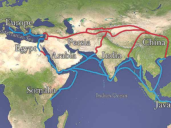
   There is no doubt that Kathmandu valley was never used as a part of the silk route but it was used by the traders and travelers as a transit point to go to Tibet and China. It was also used to go to Gandhara via Benaras, Mathura and Taxila by the Kushans.
We know that the silk route was used by the Buddhist pilgrims and traders for long. Buddhism, which flourished in the valley since the beginning of its history, might have played a role in linking Buddhist pilgrims and traders.
Since ancient times, the Western Mediterranean had trading contacts with the oriental world which were more intense than we could imagine. They took place along the caravan routes through Central Asia, and the maritime routes across the Red Sea and the Indian Ocean. India, because of its geographical position, played a role in commercial trading and cultural exchange between the East and the West. The centuries-old commercial and cultural contacts of Nepal with India might have encouraged Nepal not only to trade with India and the Western world but also to enrich its culture. Since ancient Nepal was also famous for its woolen goods, herbs, timber, precious stones and so on, If Indian spices were popular in Roman cuisines such as cardamom, nard, pepper, ginger, sesame and musk, there are possibilities that some might have gotten there from Nepal. 

  The ancient pilgrimage and trade routes from the Kathmandu valley to mainland China via Tibet is not well recorded. But we know that at the time of Lichchavis, the valley had a commercial and cultural relationship with Tibet and China. The road used by these early pilgrims and monks was also used by the traders. The Chinese Ambassador to India in the court of King Harsha Vardhan in 643 AD, Li-y-Piao came to Nepal and he was warmly welcomed by King Narendra Deva. It was at the same time that the famous Chinese businessman cum traveller Wang-Huien-Che visited Nepal.

  Among the famous visitors, in about 10th century, Gyanendra, a Tibetan saint came to Nepal to meet Acharya Santi-Rakshita. On the request of Gyanendra, Archarya Santi-Rakshita went to Tibet and again came back to Nepal after some time. According to Tara Nath, who’s written a book called History of Buddhism in India”, Vasubandhu went to Nepal accompanied by a thousand disciples in the 5th century. When King Deva Pala was ruling Bengal in the 9th century, Vajra Deva, a highly successful bard had visited Nepal and so did Samanta Bajra Deva belonging to the court of the King Deva Pala of Bengal.
During 11th century Nepali scholars like Bhiro Chana, Ratna Kriti, and Kanak Shree were at Vikram Sheel University of Bihar for studies. At that very time about 300 Chinese laborers went back to China via Nepal from the kingdom of Magadha which was under the Palas during those days. Some of these visits were in pursuit of safety. After the death of King Rathika Sena in the middle of the 12th century, Turks invaded Bihar and Bengal. They destroyed Vikramasila and massacred many ordained monks in Odantapuri. To save himself from this Muslim onslaught Acharya Ratnaraksita went to Nepal. After the Muslim devastation of Nalanda and Vikram Sheel universities of India in about 12th century, Sakya Shree Bhadra also came to Nepal. It was the time when Kubla Khan was the emperor of the Mongolian empire. 
The most famous among Nepal’s travellers at that time was probably Araniko. A group of Nepalese artists under the leadership of Araniko went to China and there they constructed numerous monuments including the famous White Pagoda. All these accounts have proved that the routes between the Kathmandu valley and Tibet and those to India were very much in use during those days. 
But the routes between the Kathmandu valley and India (either Benaras or Pataliputra or Patna) were also not well documented until the time Colonel Kirkpatrick arrived in 1793. Kirkpatrick’s account was perhaps the first scientific documentation of the routes which was used later on by numerous other British missions. Most probably, it was the same route used by the Indian and Nepali traders and pilgrims since time immemorial. The route he followed from Segouly to Kathmandu may still sounds familiar, with names like Doon-baisi, Markhoo,Chitlong, Bheem-phede, Cheesapani-fort,  Hettowara, Bechiacori, Muckwanpoor-mari and Jhuhurjhoory. From Segouly one can easily touch the Grand
Trunk Road. The inscription of King Udayadev of the 7th century AD found at Chitlong has indicated that it was one of the main villages even during the Lichchavi period. The Lichchavi inscriptions found at Tistung, the next door village of Chitlong gives further evidence that it was from this point or village numerous Nepali goods such as iron, copper utensils, wool, tails of yak and musk were exported even during the time of the Lichchavis.
Therefore, for the time being, we can conclude that the Nepal valley was connected to the Silk Route via Grand Trunk Road built by the Mughal ruler Sher Shah in the middle of the 16th century. This road was connected from Peshawar to Bengal. From Muckwanpoor a section of this Grand Trunk road via Mughalsarai can be reached very easily. From there, the connections with Benaras, Mathura, Delhi, Lahore and Peshawar were also not difficult. The connection of Kathmandu valley
to the Silk Route through the Grand Trunk Road and the ancient trails from the valley to Tibet is certainly a romantic and thrilling subject of further research by scholars. 

Shaphalya Amatya is former Director General of the Department of Archaeology, Tribhuvan University.